Insight
AI-Driven Road Surveys: Transforming Infrastructure Management
Published on January 01, 2026
Modern transportation agencies face mounting pressure to maintain aging infrastructure with limited budgets. AI powered pavement management systems and automated asset inventory tools are revolutionizing how municipalities plan maintenance, prioritize repairs, and allocate resources. By leveraging computer vision and machine learning,platforms like RoadAthena transform raw road survey data into actionable insights that enable proactive, data-driven decision-making.
The Evolution from Reactive to Proactive Maintenance
Traditional Approach
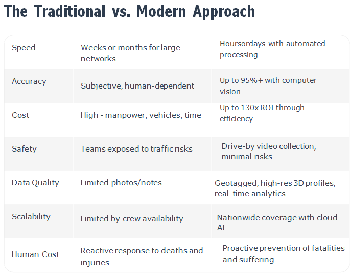
Labor-intensive manual inspections consume weeks of staff time and produce inconsistent results. Agencies operate reactively, fixing problems only after they reach critical failure. This "fix- when-broken" mentality leads to emergency repairs, budget overruns, and shortened pavement life.
AI-Powered Solution
Automated video surveys capture comprehensive road data in days, not months. Computer vision detects cracks, potholes, and defects with objective consistency. Geo-tagged condition data feeds into predictive models, enabling agencies to schedule maintenance before roads fail4extending pavement life by 2-3 years.
RoadAthena's platform uses advanced algorithms to automatically identify pavement distress from survey videos, producing consistent, geo-tagged condition data. This eliminates the variability inherent in manual inspections and creates a reliable foundation for strategic planning. The result is a fundamental shift from crisis management to strategic asset stewardship.
How AI is Transforming Road Surveys
At RoadAthena, we leverage cutting-edge technologies to make road surveys faster smarter,and more accurate
1.) Computer Vision & Machine Learning
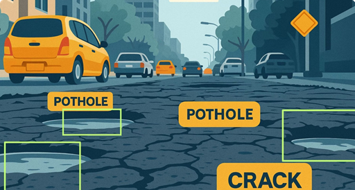
Our platform analyzes dashcam or smartphone videos to automatically detect and classify defects like potholes, cracks, ravelling, and more 4 with over 90% accuracy.
2.) Mobile Data Collection
No need for expensive specialized vehicles. Any standard vehicle fitted with a camera can collect data at normal speeds.
3.) Advanced Sensors (LiDAR, GPR)
For detailed 3D profiling and subsurface analysis, we integrate LiDAR drones and Ground Penetrating Radar (GPR) to map roughness, geometry, and hidden issues.
4.) GIS Integration & Predictive Analytics
All data is geotagged and layered on interactive maps, enabling predictive maintenance models to forecast when and where road failures will occur. Real-time analytics help prioritize repairs based on traffic volume, weather patterns, and deterioration rates 4 fixing roads before they fail and optimizing maintenance budgets.
👋 Hi! I'm Hanu AI
Hanu AI Beta v2.0
Your AI assistant